A New Approach to Mapping the Mysteries of Ocean Life
February 27, 2017
“Limitless and immortal, the waters are the beginning and end of all things on earth.” —Heinrich Zimmer
Whether landlocked or waterfront, all of us are intimately connected to the oceans. By providing shipping routes, sustaining the food chain, and producing key elements for life, the oceans support our existence and stabilize our way of life. But despite their importance, they still hold many mysteries.

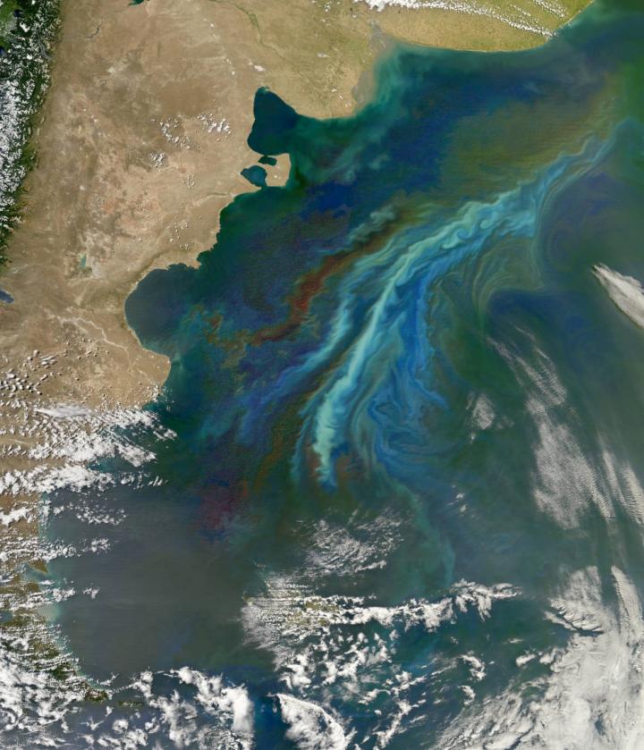
Satellites use chlorophyll's green color to detect biological activity in the oceans. The lighter-green swirls are a massive December 2010 plankton bloom following ocean currents off Patagonia, at the southern tip of South America.
Image Credit: NASA's Earth Observatory.
Beaches may appear peaceful and soothing, but their oceans are vast, extreme, and difficult to study. The smooth surface hides intense pressures and corrosive, turbulent conditions. Environmental dangers and harsh settings make some areas inaccessible. Constantly changing, the oceans move differently at different scales, swirling and flowing and mixing.
It’s hard to grasp this wilderness by taking water samples off of the side of a ship. Our knowledge about the ocean rapidly expanded in the 20th century, when electronic sensors were developed that could take measurements while submerged, sometimes for long periods of time. In addition to submersible sensors that take data on temperature, pressure, and other variables, floating sensors—or drifters—were developed that can travel with the current and provide information on surface flows. Some modern projects put dozens, or even thousands, of such drifters in the water at the same time for large-scale mapping studies.
In research recently published in the journal Nature Communications, a team of scientists from Scripps Oceanography, University of California San Diego demonstrated a swarm of underwater robots that can help us study some of the most inaccessible yet most important features of the ocean: internal waves and submesoscale processes. These water motions happen over horizontal distances of about 100 meters to 10 kilometers, and appear to play an important role in facilitating life in the oceans.
Submesocale flows are small-scale flows in which water at different depths of the ocean is stirred up and down. In particular, they can bring heat and gas from the atmosphere deeper into the ocean, and bring nutrients up to the surface layer where they are exposed to sunlight. This leads to algae growth—or at least scientists think it does. The process is difficult to explore because it happens so quickly and over small areas.
Internal waves exist below the surface of the ocean. Caused by layers of water with different densities, the waves can flow horizontally (like surface waves) or vertically. Though they can be hundreds of times larger than surface waves, they may not be noticeable from the beach or the air. Still, they are powerful processes that can significantly alter the Earth’s climate and ocean ecosystems.
Although these phenomena are not very well understood, scientists suspect that they are important in bringing together large groups (called “patches”) of plankton for mating. Dense patches of plankton can gather in wide bands, up to kilometers long, parallel to the shore. These phenomena could also be important in transporting larvae and other things through the water.
A Swarm of Autonomous Vehicles
“If we are to be good stewards of the ocean, we need to understand what lives there and how the animals interact with each other and with their environment, which means we need to be constantly seeking new and improved methods for exploration and observation.” —Edith Widder in a 2011 interview with TreeHugger

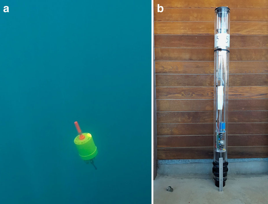
(a) A Mini-Autonomous Underwater Explorer in the ocean. (b) A floating "pinger" before being deployed (note the 30 centimeter ruler at the base for scale).
Image Credit: Jules S. Jaffe, Peter J.S. Franks, Paul L.D. Roberts, Diba Mirza, Curt Schurgers, Ryan Kastner & Adrien Boch (CC BY 4.0).
The Scripps team envisioned a new method for studying these features, one that was portable, easy to use, and gave researchers a 3-dimensional view of the activity below the surface of the ocean. Their design consists of a swarm of autonomous, floating vehicles called Mini-Autonomous Underwater Explorers (M-AUEs) that can be dropped in the water by hand from a small boat. These small vehicles can go wherever the currents take them horizontally, but are programmed to stay at the same depth like plankton. They can collect information on the waves and flows beneath the surface over distances and time. Ready to pick up your M-AUEs? They surface for recovery, sending out radio and visual signals so they can be found easily.
In order to make this design a reality, the researchers had to overcome two important physics-based challenges: controlling the depth of the M-AUEs, and mapping their location.
Controlling Depth
As an M-AUE floats beneath the surface of the ocean, changes in the water density and current can move it up or down within the water column. Since an important aspect of this study is to explore what happens at particular depths, the researchers had to develop a way for M-AUEs to stay at a programmed depth. To do this, they turned to buoyancy.
If you place an object in water, the force of gravity pushes it down. The more massive the object is, the greater the force of gravity. But, at the same time that gravity is pushing the object down into the water, there is another force pushing up on the object from the water beneath, the buoyant force. Whether an object will sink, float, or stay somewhere in the middle depends on the difference between the force of gravity and the buoyant force. This is because that fluid also feels the downward pull of gravity, “fighting” gravity’s downward pull on the object.
The buoyant force is described by Archimedes’ principle, which says that an object completely or partially immersed in a fluid is pushed up by a buoyant force equal to the weight of the fluid displaced by the object. In other words, the buoyant force can be changed by changing the density of the object—to float higher, decrease the density. To float lower, increase the density.
Density depends on mass and volume, and since you can’t very well change the mass of an M-AUE in action, the vehicles are programmed to adjust their buoyant force by changes in volume. Each M-AUE has a small computer-controlled piston. When an M-AUE starts floating higher or lower than it is supposed to, the piston is activated that makes the volume of the M-AUE either slightly bigger or slightly smaller, depending on the situation.
Mapping Locations
One of the motivations for this project is to see how objects submerged at these submesoscale depths move over time. However, this requires an accurate positioning system that provides the location of each M-AUE at regular time intervals. This seems like it’d be an easy task given the prevalence of GPS trackers, but GPS signals don’t penetrate very deep underwater so that’s not an option for the M-AUEs.
To meet this challenge, the team designed an array of five surface floats. These floats do have GPS trackers (their heads stay above water) and they produce pings at regular time intervals. The sounds are synchronized, so one float pings first, then the next, and so on in a round-robin fashion. These “pingers” are positioned around where the M-AUEs are deployed. The sound waves from each ping travels through the water to each M-AUE, where they are recorded.
Once the M-AUEs are retrieved after an experiment, their positions in time can be mapped through a kind of triangulating process. With information on the position of each of the pingers, the time at which each ping sounded, the time it takes each ping to reach a given M-AUE, the depth of each M-AUE, and how fast sound travels through the ocean, a computer program can work out the position of each M-AUE at the time of each set of pings. While other sound-based positioning designs are possible, this one keeps the M-AUEs small and inexpensive.
The First Experiment
"But the influence of the sea on man’s daily life and on his future well-being is so great and still so poorly comprehended that the sea must be explored, studied, and understood so that it can be taken into account more intelligently whenever man is faced with any problem relating to his physical environment.” —H. B. Stewart in Deep Challenge
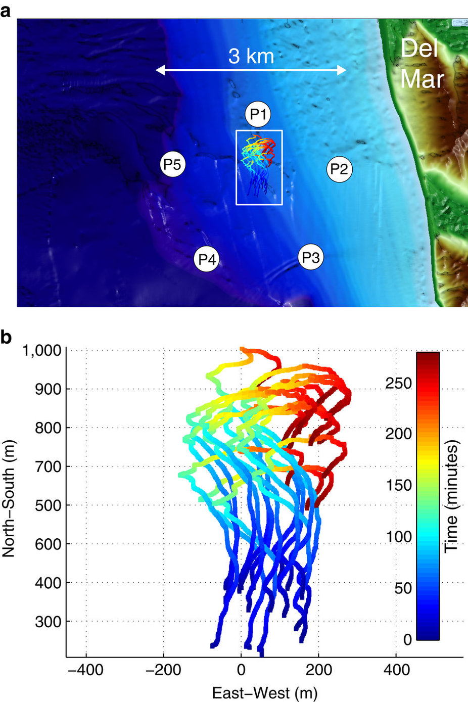
In a first test of their design, the team deployed the M-AUEs and floaters for five hours not too far from the coast of San Diego, California. The M-AUEs were programmed to stay at a depth of 10 meters. Information on their location was taken every 12 seconds using pings and pressure sensors. Since all of the M-AUEs stayed at the same depth, together they were able to detect and quantify the properties of the submesocale flows and internal waves in the region.

This image shows the locations of the 5 pingers (P1–P5) and the paths of 16 M-AUEs during the 5-hour deployment. Each trajectory is colored according to the time since deployment, ranging from blue to red.
Image Credit: Jules S. Jaffe, Peter J.S. Franks, Paul L.D. Roberts, Diba Mirza, Curt Schurgers, Ryan Kastner & Adrien Boch (CC BY 4.0).
One of the goals of the experiment was to see whether the M-AUEs would spontaneously accumulate in the same way that scientists think plankton do, over the troughs of internal waves. Their results showed this very thing happening: in some cases the M-AUEs that accumulated stayed together for several minutes. This supports the theory that the ocean’s internal waves play an important role in plankton mating, feeding, and even infection rates.
Moving Forward
"Knowledge of the oceans is more than a matter of curiosity. Our very survival may hinge upon it.” —President John F. Kennedy, Jr. in a March 1961 message to Congress.
This experiment highlighted one specific case in which M-AUEs are uniquely equipped to gather data, but there are many others. The researchers say this system could be used to study the ways that many things move through the ocean, including eggs, sperm, larvae, harmful algal blooms, and subsurface oil spills. Researchers could also track ships, whales, earthquakes, and other objects by studying how the sounds they generate move through the swarm. This could be a very powerful information-gathering system, especially when combined with aerial observations and other data-collecting methods.

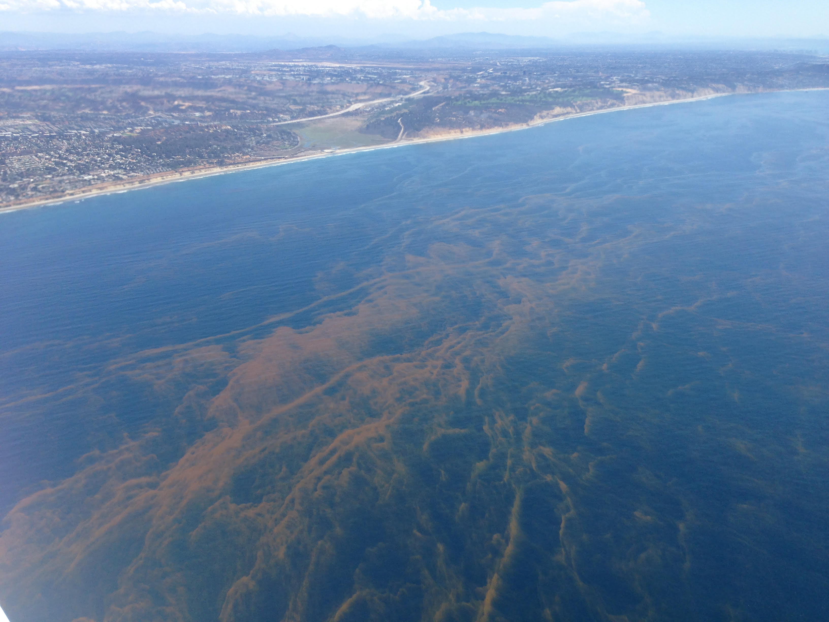
This photograph was taken looking southeast toward San Diego, CA, at the location of the study. The patterns in the water are bands of phytoplankton that formed during a red tide.
Image Credit: Peter Franks.
In light of these opportunities, the researchers are working to optimize the design so that it can be used for longer periods of time and over larger areas. “Use of these M-AUE swarms will provide unique and powerful new insights into a wide range of otherwise intractable physical and biological problems in the ocean,” say the researchers.
“The sea is everything. It covers seven tenths of the terrestrial globe. Its breath is pure and healthy. It is an immense desert, where man is never lonely, for he feels life stirring on all sides. The sea is only the embodiment of a supernatural and wonderful existence. It is nothing but love and emotion; it is the Living Infinite.” —Jules Verne in Twenty Thousand Leagues Under the Sea.
—Kendra Redmond


